GEOS WT Course - GIS Using Google Earth
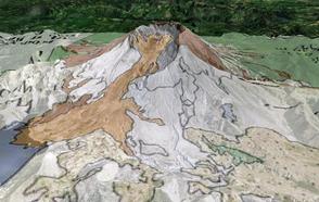
Google Earth image of Mt. St. Helens volcano draped with a geologic map overlay.
January 31, 2012
Participants in the GIS Using Google Earth on-campus 2012 Winter Term course learned a variety of technical skills for creating media-rich content for Google Earth. The course began with a series of lectures and exercises to develop these skills, and then students were charged to develop a Google Earth project on the topic of their choice.
These projects were designed to utilize Google Earth as a tool to draw new connections between data and/or information associated with their topic that might not have been obvious without visualizing the material in a spatially meaningful context. While working on their projects, students not only acquired valuable technical skills in working with images/videos/text, but they also developed a deeper understanding of their topic as they visualized/analyzed their data in Google Earth. Students presented their projects on January 25, 2012, and published photo books describing their work for display later in the year at DePauw's GIS Day.
Prof. Scott Wilkerson taught this course.