GEOS 315: Map Interpretation Field Trip - Glacial Deposits & Landforms, IL
November 3, 2016
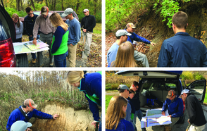
On Thursday, November 3, Professor Scott Wilkerson and some members of the GEOS 315: Map Interpretation class participated on a field trip to the glaciated terrain of central Illinois led by Dr. Dave Grimley (Associate Quaternary Geologist) with the assistance of Dr. Olivier Caron (Associate Quaternary Geologist) of the Illinois State Geological Survey.
The group first traveled along the crest of the Pesotum end moraine and then the Champaign end moraine, making a stop to view the topographic expression of these moraines and to discuss their map patterns in context of glacial/interglacial regional events. The group then rolled up their sleeves (and got out their shovels and mattocks) to investigate exposures of loess, till, and pro-glacial deposits along the Sangamon River. There they saw the classic depositional sequence associated with the advance of a glacial ice sheet, and remarkably, visited an exposure with buried wood in the sub-till layers that could be used to carbon-date those layers. After lunch, they studied outwash and loess deposits in some sand and gravel pits southwest of Mahomet, IL. Drill holes and exposures in this area helped constrain the interpretation that this modern stream valley may be positioned above deposits of paleo-stream valleys present during glaciation. The group also studied the soil profile in the area showing a transition from disturbed soil to loess with zones of both leaching and accumulation to outwash deposits. Lastly, the trip concluded by traveling over the Cerro Gordo end moraine to look at another exposure along the river where the outwash was deposited on top of the till and pro-glacial deposits that correlated with the earlier field trip stops. Here, a very dark peat layer suggested that the pro-glacial area probably was a site of a laterally extensive bog. The group discussed how this bog might have formed, including swampy areas impounded by moraines and possibly an isostatic adjustment to the weight of the ice sheet. Overall, the trip was not only great in terms of learning about glacial landforms/deposits and soils, but also about how Quaternary geologists approach mapping and actually draw contacts (both solid and dashed) on their maps and cross sections.
The Department of Geosciences sincerely thanks Dave and Ollie for conducting this trip, and the ISGS for supporting this endeavor!